 | Impact of the ellipsoidal height difference among the points - Datasets |
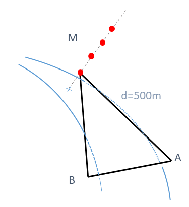
Using a network of side length 500 m, the initial ellipsoidal height of point M (433.665 m) if modified by the addition of offsets starting from 30 m up to 2500 m.
For each network, identified by its offset value to the initial ellipsoidal heigth of point M, ETRS89 geodetic Cartesian coordinates for all points, and generated observations between points are provided.
All data in a zip file
For each offset value f on the ellipsoidal height of point M, the ETRF89 geodetic Cartesian coordinates for points A,B and M are compiled in a file named f_coord.csv
For each offset value f on the ellipsoidal height of point M,, the direction (grads), zenital angle (grads) and slope distance (meters) are compiled in a file named f_meas.csv
Zip file containing all the datasets (CSV format): Datasets.zip
Offset on the ellipsoidal height of point M : 30 m
| Coordinates | | Point | ETRF89 X (m) | ETRF89 Y (m) | ETRF89 Z (m) | | A | 4395484.55040 | 466045.37790 | 4583365.60400
| | B | 4395523.48320 | 465546.70400 | 4583351.16100
| | M | 4395213.69330 | 465765.27510 | 4583679.57860
|
|
| Local coordinates (in the local astronomical system of point P0) | | Point | North (m) | East (m) | Up (m) | | A | -144.33755 | 250.00001 | 10.00003
| | B | -144.33755 | -250.00001 | -9.99996
| | M | 288.67655 | 0.00003 | 30.00000
|
|
| Measurements | | From | To | Direction (grad) | Zenital angle (grad) | Slope distance (m) | | A | B | 240.01943311 | - | -
| | A | M | 306.68590137 | 97.45762674 | 500.40364000
| | B | A | 361.25837354 | - | -
| | B | M | 294.59208478 | 94.92014437 | 501.60231000
|
|
Offset on the ellipsoidal height of point M : 50 m
| Coordinates | | Point | ETRF89 X (m) | ETRF89 Y (m) | ETRF89 Z (m) | | A | 4395484.55040 | 466045.37790 | 4583365.60400
| | B | 4395523.48320 | 465546.70400 | 4583351.16100
| | M | 4395227.45040 | 465766.73290 | 4583694.02220
|
|
| Local coordinates (in the local astronomical system of point P0) | | Point | North (m) | East (m) | Up (m) | | A | -144.33755 | 250.00001 | 10.00003
| | B | -144.33755 | -250.00001 | -9.99996
| | M | 288.67740 | -0.00003 | 50.00001
|
|
| Measurements | | From | To | Direction (grad) | Zenital angle (grad) | Slope distance (m) | | A | B | 238.84555596 | - | -
| | A | M | 305.51201392 | 94.92062577 | 501.60168000
| | B | A | 230.59011452 | - | -
| | B | M | 163.92382381 | 92.39921972 | 503.59302000
|
|
Offset on the ellipsoidal height of point M : 100 m
| Coordinates | | Point | ETRF89 X (m) | ETRF89 Y (m) | ETRF89 Z (m) | | A | 4395484.55040 | 466045.37790 | 4583365.60400
| | B | 4395523.48320 | 465546.70400 | 4583351.16100
| | M | 4395261.84300 | 465770.37750 | 4583730.13130
|
|
| Local coordinates (in the local astronomical system of point P0) | | Point | North (m) | East (m) | Up (m) | | A | -144.33755 | 250.00001 | 10.00003
| | B | -144.33755 | -250.00001 | -9.99996
| | M | 288.67970 | -0.00005 | 100.00003
|
|
| Measurements | | From | To | Direction (grad) | Zenital angle (grad) | Slope distance (m) | | A | B | 241.72870800 | - | -
| | A | M | 308.39515884 | 88.66462284 | 508.04372000
| | B | A | 289.11128651 | - | -
| | B | M | 222.44499789 | 86.21682802 | 511.96212000
|
|
Offset on the ellipsoidal height of point M : 250 m
| Coordinates | | Point | ETRF89 X (m) | ETRF89 Y (m) | ETRF89 Z (m) | | A | 4395484.55040 | 466045.37790 | 4583365.60400
| | B | 4395523.48320 | 465546.70400 | 4583351.16100
| | M | 4395365.02080 | 465781.31140 | 4583838.45850
|
|
| Local coordinates (in the local astronomical system of point P0) | | Point | North (m) | East (m) | Up (m) | | A | -144.33755 | 250.00001 | 10.00003
| | B | -144.33755 | -250.00001 | -9.99996
| | M | 288.68651 | -0.00000 | 249.99999
|
|
| Measurements | | From | To | Direction (grad) | Zenital angle (grad) | Slope distance (m) | | A | B | 240.60492572 | - | -
| | A | M | 307.27132927 | 71.51289585 | 554.63109000
| | B | A | 200.28488906 | - | -
| | B | M | 133.61865660 | 69.47605354 | 563.56987000
|
|
Offset on the ellipsoidal height of point M : 500 m
| Coordinates | | Point | ETRF89 X (m) | ETRF89 Y (m) | ETRF89 Z (m) | | A | 4395484.55040 | 466045.37790 | 4583365.60400
| | B | 4395523.48320 | 465546.70400 | 4583351.16100
| | M | 4395536.98390 | 465799.53450 | 4584019.00380
|
|
| Local coordinates (in the local astronomical system of point P0) | | Point | North (m) | East (m) | Up (m) | | A | -144.33755 | 250.00001 | 10.00003
| | B | -144.33755 | -250.00001 | -9.99996
| | M | 288.69777 | -0.00001 | 499.99998
|
|
| Measurements | | From | To | Direction (grad) | Zenital angle (grad) | Slope distance (m) | | A | B | 239.43095838 | - | -
| | A | M | 306.09734920 | 50.64677882 | 700.09049000
| | B | A | 69.61662324 | - | -
| | B | M | 2.95040523 | 49.37365589 | 714.22665000
|
|
Offset on the ellipsoidal height of point M : 1000 m
| Coordinates | | Point | ETRF89 X (m) | ETRF89 Y (m) | ETRF89 Z (m) | | A | 4395484.55040 | 466045.37790 | 4583365.60400
| | B | 4395523.48320 | 465546.70400 | 4583351.16100
| | M | 4395880.91000 | 465835.98070 | 4584380.09450
|
|
| Local coordinates (in the local astronomical system of point P0) | | Point | North (m) | East (m) | Up (m) | | A | -144.33755 | 250.00001 | 10.00003
| | B | -144.33755 | -250.00001 | -9.99996
| | M | 288.72045 | -0.00001 | 999.99996
|
|
| Measurements | | From | To | Direction (grad) | Zenital angle (grad) | Slope distance (m) | | A | B | 242.31732168 | - | -
| | A | M | 308.98377494 | 29.77800988 | 1109.12097000
| | B | A | 180.75289545 | - | -
| | B | M | 114.08661695 | 29.26886104 | 1127.00269000
|
|
Offset on the ellipsoidal height of point M : 1500 m
| Coordinates | | Point | ETRF89 X (m) | ETRF89 Y (m) | ETRF89 Z (m) | | A | 4395484.55040 | 466045.37790 | 4583365.60400
| | B | 4395523.48320 | 465546.70400 | 4583351.16100
| | M | 4396224.83610 | 465872.42690 | 4584741.18520
|
|
| Local coordinates (in the local astronomical system of point P0) | | Point | North (m) | East (m) | Up (m) | | A | -144.33755 | 250.00001 | 10.00003
| | B | -144.33755 | -250.00001 | -9.99996
| | M | 288.74312 | -0.00001 | 1499.99994
|
|
| Measurements | | From | To | Direction (grad) | Zenital angle (grad) | Slope distance (m) | | A | B | 241.14331736 | - | -
| | A | M | 307.80984075 | 20.61644613 | 1571.67113000
| | B | A | 50.08476359 | - | -
| | B | M | 383.41841468 | 20.36155498 | 1590.65153000
|
|
Offset on the ellipsoidal height of point M : 2000 m
| Coordinates | | Point | ETRF89 X (m) | ETRF89 Y (m) | ETRF89 Z (m) | | A | 4395484.55040 | 466045.37790 | 4583365.60400
| | B | 4395523.48320 | 465546.70400 | 4583351.16100
| | M | 4396568.76230 | 465908.87310 | 4585102.27590
|
|
| Local coordinates (in the local astronomical system of point P0) | | Point | North (m) | East (m) | Up (m) | | A | -144.33755 | 250.00001 | 10.00003
| | B | -144.33755 | -250.00001 | -9.99996
| | M | 288.76572 | -0.00002 | 1999.99999
|
|
| Measurements | | From | To | Direction (grad) | Zenital angle (grad) | Slope distance (m) | | A | B | 330.44059261 | - | -
| | A | M | 397.10715667 | 15.67627610 | 2051.86897000
| | B | A | 69.03982315 | - | -
| | B | M | 2.37343096 | 15.52625597 | 2071.27852000
|
|
Offset on the ellipsoidal height of point M : 2500 m
| Coordinates | | Point | ETRF89 X (m) | ETRF89 Y (m) | ETRF89 Z (m) | | A | 4395484.55040 | 466045.37790 | 4583365.60400
| | B | 4395523.48320 | 465546.70400 | 4583351.16100
| | M | 4396912.68840 | 465945.31930 | 4585463.36670
|
|
| Local coordinates (in the local astronomical system of point P0) | | Point | North (m) | East (m) | Up (m) | | A | -144.33755 | 250.00001 | 10.00003
| | B | -144.33755 | -250.00001 | -9.99996
| | M | 288.78846 | -0.00002 | 2500.00005
|
|
| Measurements | | From | To | Direction (grad) | Zenital angle (grad) | Slope distance (m) | | A | B | 329.65789651 | - | -
| | A | M | 396.32450380 | 12.62101540 | 2539.72098000
| | B | A | 115.26109514 | - | -
| | B | M | 48.59465955 | 12.52285546 | 2559.33927000
|
|


